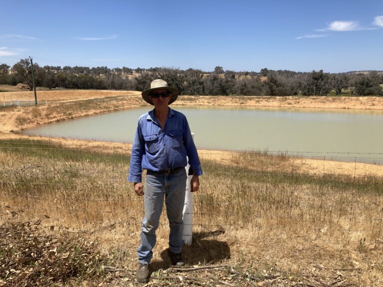
On his last farm, Martin had 20 of these banks all connected to dams.
It’s important to note that building banks can be a risky business, so it is best to confer with an engineer or at least someone with training and experience to design and survey the bank to minimise the risk of failure and degradation.
Anyone intending to drain or pump groundwater on their property are also reminded to lodge a Notice of Intent with the Soil and Land Commissioner before proceeding.
At the end of each bank, Martin installed a pair of 2-inch poly pipes with holes drilled in them which carries water from the lowest end of the bank, underground and into the dams.
“The dam is completely sealed off from other water flow, so apart from direct rainfall, it only gets water from the bank,” he said. “It makes a huge difference to water quality because it’s all clean water. Only what can go through a 2 inch pipe will get in the dam.
“The bank has the capacity to hold a lot of water and slowly run through the pipes, so if there is any runoff from the paddock it settles in the bank channel and not in the dam.
“Maintenance is low, you’ve only got to make sure the pipes (into the dam) are clear,” he said.
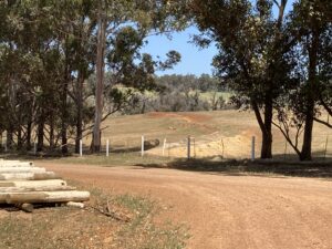
Martin constructs the bank so it is higher than the ground in front of the channel and is big enough to act as a settlement pond.
“It’s been up to half full of water after a thunderstorm. You’ve got to make sure you’ve got the capacity to hold storm water without it washing the bank away,” he said.
Speaking with an engineer can help size banks, with bigger banks required for bigger catchment areas and slopes.
“I prefer to have seepage water (seeping into the channel in front of the bank) compared to runoff. The seepage comes in above the (50 cm deep) clay layer and below the topsoil. Just seeps in very slowly.”
Martin believed the practice is a better option for medium rainfall areas such as Boyup Brook, whereas lower rainfall areas may be more suited to roaded catchments.
“In some areas roaded catchments are your only option because you don’t have the ability to get seepage water and you might only get 1-2 decent rains in a year,” he said.
Martin outlined some potential issues with drainage banks if they weren’t constructed well.
“Too many people implement it without getting the levels right. And they don’t understand the bank has to have a clay seal,” he said.
Key to an effective bank was a clay seal which required the site to have a clay subsoil near the surface (e.g. no more than 50 cm deep).
“If you’ve got dry topsoil that is not protected by a seal, and a big heap of water hits it, there’s nothing to hold the water so it goes straight through and washes it out,” he said.
“Or your banks will leak, and where they leak you will end up with a salt scald on the other side of the bank. You’ve got to have a clay seal on the front to hold the water.”
Salinity is another consideration for farmers, and banks should be in areas with low salinity risk
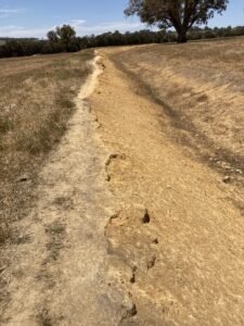
To establish the bank, Martin uses a laser level to mark out the position of the bank on a slight grade (e.g. 0.1%) towards the dam.
The bank is constructed using a contractor with a D6 bulldozer or larger, with a deep drop blade that can remove all the topsoil/sand (about 50 cm deep in his case) in one push.
Before pushing any soil, the surveyed line is ripped to the depth of the sandy topsoil and this is pushed up to form the downslope side of the bank and leaves the clay subsoil exposed and completely free of topsoil.
He then rips and pushes the exposed subsoil up to form the upslope side of the bank with a clay seal pushed up to the top of the bank.
Martin emphasises not mixing the sandy topsoil and clay subsoil.
“It’s important to have a clean clay subsoil to push up in the second push to get a good seal,” he said.
Another common problem was not having a safe overload where excess water build-up can safely escape.
“At the end of the banks there is a level sill that is lower than the lowest point along the top of the bank. So in the event of a 3-4 inch rainfall event, water can get away out the end and bypass the dam,” he said.
For more information, see Surface Water Management in WA, Seepage Interceptor Drains, and speak to an experienced advisor.
For other options, visit the WaterSmart Dams webpage.
This case study is supported by the SW WA Drought Hub, through funding from the Australian Government’s Future Drought Fund.
This case study is for general information only. If you are intending to construct a bank, you should consult an experienced professional for assistance with drain design. Poor design and layout can result in high maintenance and be costly to correct.
More helpful resources are available via the below link.