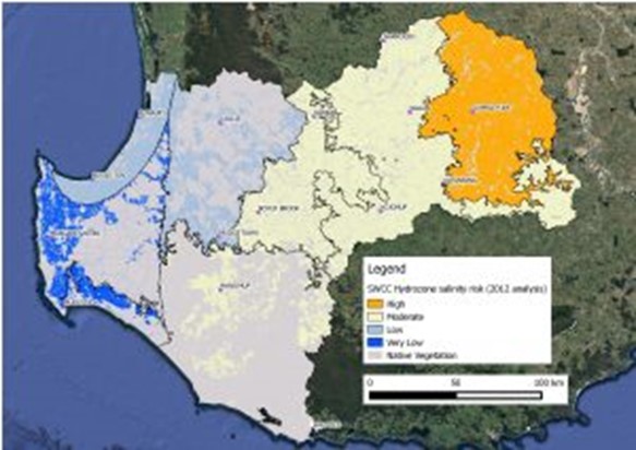
Figure 1. Hydrozone salinity risk in the SWCC region, based on DPIRD analysis from 2012.
With decreasing rainfall, there has been an expectation that the area affected by dryland salinity has peaked. However, recent observations by farmers that salinity is expanding in many areas have been verified through groundwater monitoring by the Department of Primary Industries and Regional Development (DPIRD), particularly where clearing of native vegetation or plantations has been relatively recent.
In 2012, DPIRD analysed groundwater trends from 1500 surveillance bores to assess salinity expansion risk across the south-west agricultural region (Geraldton to Esperance). The region was split into “hydrozones”, or areas with similar hydrogeology, climate, landscape and farming systems to help characterise trends within smaller geographical areas.
The analysis revealed that 82% of the region had a moderate risk of increasing salinity, 10% had a high risk and only 8% had a low risk (Figure 1).
In the South West NRM region, most hydrozones had a moderate or low risk of increasing salinity. However, the South-Western Zone of Ancient Drainage (roughly between Wagin and Lake Grace, extending from Katanning in the south to Corrigin in the north) was classified as a high salinity risk due to a dominance of rising groundwater trends and its broad, flat valley floors. Sandy soils and more recent clearing events in much of the hydrozone contribute to the high risk of expanding salinity, despite declining rainfall. It is worth noting that the expansion of salinity due to past clearing is likely to continue rising beyond 2040.
Since the 2012 assessment, the most significant event to impact groundwater trends in the SWNRM region was a series of unseasonal rainfall events in February 2017, which caused increased rates of groundwater rise in the south-east of the region. These had generally returned to their previous trends by 2019-20.
In 2019-20, groundwater levels started to fall or stabilise in the Western (Collie) and Eastern (Darkan / Boyup Brook) Darling Range, Warren-Denmark (Manjimup / Walpole) and parts of the Southern Zones of Rejuvenated Drainage (Narrogin / Kojonup) hydrozones within the SWNRM region, where decadal trends of reduced annual rainfall have occurred.
However, at a smaller scale within hydrozones, groundwater level rises of up to one metre per year were observed in the Eastern Darling Range and Warren-Denmark hydrozones where blue gum plantations had been harvested or removed. As the unseasonal rainfall events of February 2017 did not reach this far west, these groundwater rises are attributed solely to the removal of the plantations and are expected to continue for some time.
So, despite the trend of a drying climate, the risk of dryland salinity is still real, especially where clearing of native vegetation or plantations has been more recent. DPIRD is currently undertaking another salinity risk assessment for the whole south-west agricultural region in partnership with CSIRO, expected to be published in 2021.
For information on managing dryland salinity, visit this DPIRD link.
This article was co-authored with Dr Paul Raper, Water Research Scientist DPIRD.