
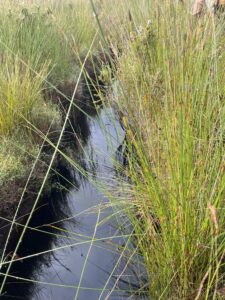
 Peatlands are one of southwestern Australia’s most under-recognised ecosystems, yet they play a critical role in supporting biodiversity, regulating water systems and storing significant amounts of carbon accumulated over thousands of years.
Despite this, peatland systems across the South West and Great Southern regions remain relatively under-mapped and under-studied, and are increasingly under pressure from a drying climate, altered fire regimes and land use change.
The PEAT Southwest project, Protecting Peatland Ecosystems and Addressing Threats in Southwestern Australia, is addressing this gap through a coordinated, multi-partner effort to improve understanding and inform long-term management of these systems.
Co-led by The University of Western Australia and Edith Cowan University, and guided by Noongar Elders, the project brings together a broad network of research, government and regional delivery partners, including South West NRM, South Coast NRM, the Walpole Nornalup National Park Association, the Department of Biodiversity, Conservation and Attractions (DBCA), Undalup Association, the Western Australian Museum and Biologic Environmental.
A coordinated, multi-disciplinary program of work
The project is structured around a series of interrelated objectives aimed at building a comprehensive understanding of peatland systems and translating that knowledge into practical management outcomes.
This includes:
- Strengthening collaboration between local knowledge holders, Traditional Custodians and technical specialists;
- Improving understanding of peatland distribution, geodiversity and biodiversity;
- Developing management approaches to guide priority actions;
- Progressing on-ground implementation across the extent of Empodisma peatlands.
Together, these objectives reflect a deliberate progression from knowledge generation through to application, ensuring research outputs can inform real-world outcomes.
Regional delivery underway across the South West
Within this broader framework, South West NRM is supporting regional implementation, with Project Manager Lorraine Duffy coordinating early-stage activity and engagement across the South West as the expanded regional work gets underway.
At this stage of the project, work is focused on establishing partnerships with sub catchment and ranger groups, identifying potential landholders with peatland occurrences and refining tools with the PEAT team including a rapid field assessment App and User Guides to help others identify peat, peatland species and threats.
Building on earlier work in the Walpole Wilderness Area, teams are extending geographic mapping efforts using a combination of:
- Existing wetland datasets;
- Indicator species and previous vegetation community mapping;
- Local knowledge from landholders, catchment groups and the Department of Biodiversity Conservation and Attractions.
Where predictive mapping data has been limited, regional teams are working together to develop alternative ways of identifying potential peatland areas.
This reflects the current phase of the project: one that is iterative, collaborative and focused on building a robust evidence base to inform future action.
Embedding genuine partnership with Traditional Owners
Engagement with Traditional Owners is a central component of the project’s design and delivery. This 5 year research collaboration (2023-2028) has been led by UWA and ECU and guided by Minang and Wadandi-Pibbulman Elders.
South West NRM and project partners are working with Indigenous land use agreement groups including Karri Karrak and Wagyl Kaip, alongside South Coast NRM’s engagement across its region.
Importantly, this engagement is focused on co-design and meaningful participation, with current activity centred on:
- Establishing relationships;
- Identifying areas of interest;
- Understanding how Traditional Owners would like to be involved in on-ground work.
Upcoming on-country meetings will support this next phase, ensuring project activities align with community priorities and local knowledge.
Tools and systems supporting data collection
Alongside field-based work, the project is adapting and applying tools developed through earlier phases of research.
This includes the use of a rapid field assessment App to help teams consistently record and map data and compare information across peatland sites.
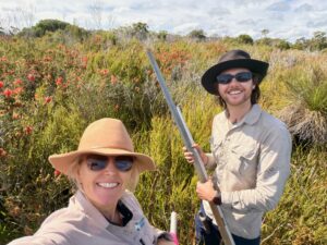
Lorraine Duffy, Project Manager South West NRM and Josh Hungerford, PEAT Southwest Toolkit Coordinator, UWA testing the Rapid Field Assessment App
As part of this work, South West NRM Project Manager Lorraine Duffy has been working in the field with UWA researcher Josh Hungerford to trial an NRM version of the Rapid Field Assessment App across peatland sites in the South West.
Field visits are supporting both data collection and verification of potential peatland areas on the ground. In some cases, this has included identifying sites that are not currently captured in available datasets, highlighting the ongoing gaps in peatland mapping across the region.
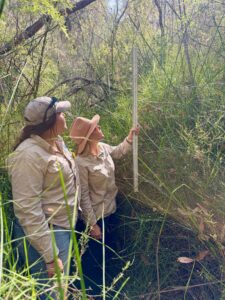
South West NRM Technical Officer Jade Riley (left), and Program Manager Lorraine Duffy measuring Empodisma height.
Vegetation condition is also being assessed during these visits, with the structure and height of key peat-forming species such as Empodisma recognised as indicators of peatland health. Taller, denser growth can indicate long-unburnt, relatively intact systems.
These on-ground activities which engage land managers and community, contribute to a detailed and practical understanding of peatlands, their distribution and condition, complementing broader mapping and predictive mapping efforts.
Laying the foundation for future management and action
While current activity is focused on mapping and engagement, this work is designed to underpin the next stages of the project.
This will include:
- Prioritising peatland systems across the landscape;
- Developing management and on ground approaches to manage threats;
- Events and activities to build community understanding of peatlands;
- Supporting landholders with planning and decision-making on practical ways of protecting and restoring peatlands where needed;
- Delivering targeted on-ground actions over time.
Mapping and identification efforts are expected to continue throughout the life of the project, reflecting both the scale of the task and the current gaps in knowledge.
For more information about the PEAT Southwest project, visit the project website or South West NRM’s project overview.
This project is funded by Major Supporter Lotterywest and the Ian Potter Foundation. It is co-led by the University of Western Australia and Edith Cowan University, with collaborative partners Undalup Association, the Department of Biodiversity, Conservation and Attractions, the Western Australian Museum, the Walpole-Nornalup National Park Association, Biologic Environmental, South West NRM and South Coast NRM.